Backbone Mountain, Tubing the Upper Yough and Hiking Big Savage

This weekend is dedicated to a woman named Christine whom I met last year around this time. Christine and I got to talking about Backbone Mountain, which is the highest point in Maryland. I had just finished reading an article about it where the write said it was pretty unfabulous, Christine quickly lost her temper with me in a spectacular fashion, she claimed to have been there and said it was a rugged and exciting climb to the top. The only conclusion my group of friends and me reached from this discussion was that Christine had an anger management issue. So I devoted this weekend to finding the truth about Backbone Mountain.

I had remembered reading about Mountain Lake Park in Garrett County and vaguely recalled there were supposed to be beautiful Victorian homes there. I decided that would be my travel objective on Friday night. Upon my arrival I quickly found the mountain lake but no gorgeous Victorian homes, MLP turned out to be a disappointment. I traveled on to Oakland for the evening where I caught up with the Little Yough Summer Music Festival featuring that night Sarah Lee Guthrie and Johnny Irion. My advice to those two is don’t quit your day job and practice more.

I decided to head back to an apartment complex in MLP to bed down for the evening. I entered the complex quietly and parked off to the side in a parking area. It was hot in the minivan so I took off my clothes and slipped into my sleeping bag. 10 minutes after retiring for the evening I hear a police siren. A police cruiser arrives in the parking lot and parks right next to my minivan. I figured somebody in the apartment complex became suspicious when nobody had exited my vehicle and called the police. 2 minutes later another police cruiser arrives and parks on the other side of my minivan. I stay still assuming that I will be questioned thoroughly. Then a fire engine arrives and parks directly behind my car. Between all the blue, yellow and red lights, the interior of my car is lit up like a Christmas tree on steroids. This seems like a lot of firepower for one middle-aged woman sleeping in her car and I figure I might be spending the night in the lock-up. I am sure there is some sort of rule in Garrett County about sleeping in your car naked on private property.

I hear the public servants talking but I dare not rise to find out what is going on. Then I hear the police and firemen walk toward the apartment complex and away from my car. I can’t see what is happening or why they were there but apparently the armory was not called on my behalf. Eventually the emergency personnel leave without noticing me and I drift off to sleep.
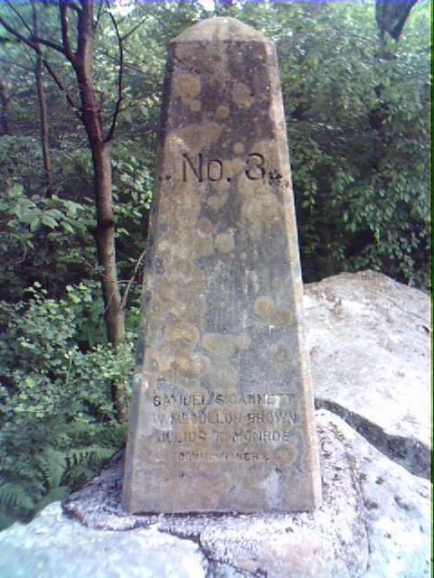

The next day I rise early and head off toward Backbone Mountain. People on the Internet suggest giving oneself 40 minutes to climb to the top. I decided to give myself 20 and take off. I arrive at the summit in 21 minutes. The place is definitely unfabulous. There is a marker denoting the peak at the top.

Afterwards I stupidly decide to tube the Upper Youghiogheny between Swallows Falls and Hoye’s Run. Kids, don’t try this at home. I failed to do my homework and it turns out there is some serious whitewater not suitable for a float tube between the two points. I had a wonderful time but had to portage around some of the trickier areas. I also passed by where they perform the dam release for the Upper Young, that is some serious scary equipment the utility company has where I wouldn't want to be anywhere near that place when they let the water free.


On Sunday I decided to return to Savage Mountain and actually find the Southern trailhead this time. The campground was completely empty, unlike Memorial Day, I was able to enjoy this trail with beautiful weather. Figuring that I wouldn’t pass anyone I decided to hike up the mountain without my clothes on. I found some neat rocky outcroppings at the top. Before I descended I decided to put my clothes back on which was a good thing because I did meet one other hiker. This man’s name was Ron and he was a professor at the University of Pittsburgh, Johnstown Campus. Turns out he lives on Washington Street in Cumberland, one of my favorite neighborhoods.

Tubing on the Gunpowder

UPDATE 7/8/06 For another Cham post with pics about tubing on the Gunpowder please go here

ANOTHER UPDATE 6/24/08 I'm working on another Cham post about Gunpowder tubing, this one will have a video and a map!

As some of you know, I work in Hunt Valley which gives me access to all the fun in Northern Baltimore County. Yesterday I decided to inflate my tube while sitting in my cube(hey, that rhymes!) and then take off to Hicks Road for some tubing fun. When I got to the intersection of Bee Tree Run and Hicks at 5:30PM it started to pour. This probably should have dissuaded me from attempting this as it would any normal person, but it didn't. I waited out the rain in my car and then descended into the run. A cool mist settled over the water and visibility was about 10 feet. I could have seen better in a snow blizzard.

I needed to go about 3 miles to Monkton where I left my bike and I didn't get started until a little after 6PM. I never tubed this area before so it was a crap shoot whether I would get done before dark or not. At sundown and in the mist this area becomes incredibly creepy. At one point I heard a terrible noise and noticed some sort of large bird, maybe a crane, swooping down over me in anger, I guess it wasn't pleased I was in the river. Since it had rained hard there were a fair amount of rapids which made tubing fun and fast.

When I hit the confluence of Bee Tree and the Gun Powder the water temperature dropped by 20 degrees, the Gun Powder must hail from some sort of freezing underground spring. The air temp was in the 90 degrees F and I had goose bumps all over my legs.

I arrived Monkton a little after 8PM with great relief since I had a few minutes of dusky daylight left. I deflated my tube, put it in my backpack and headed north on the NCRT back to my car. It took me a scant 15 minutes to bike what it took me 2 hours to tube.

Harbor Summer 2005


I took this picture yesterday morning around 6AM from my kayak. I like it.

Tubing on the Potomac near Paw Paw and Western Maryland Rail Trail

Tubing on the Potomac near Paw Paw

View Tubing on the Potomac North of Paw Paw in a larger map

Ever since I bought my tube float a few weeks ago I wanted to think if there was a way to incorporate a bike ride with a trip down a river. I also wanted an excuse to explore the Green Ridge State. I had had such a good time at Paw Paw, WV 2 weeks ago I wanted to return and spend some more time in that region. I left Saturday morning with a couple of day’s worth of food, my tube, my bike, a tent and minimal gear.

The forest is a set of small hills and valleys with a labyrinth of logging roads crisscrossing it. The ride through was a little treacherous. Even though there were lots of official Maryland State campsites sprinkle among the trees, almost nobody was camping. I decided Paw Paw was to be my tubing endpoint destination and I dropped my bike off near the tunnel and proceeded up the road about 6 miles at a place called Town Creek Aqueduct.

Within seconds of my arrival I had locked my car and popped my tube in the Potomac and I was off. I waved to some local boys who had set up camp. It took me 3 hours to go 6 miles in the river, where I hit about 3 sets of Class I&II rapids otherwise my trip down river was pretty uneventful.

I found my bike and switched the lock to the tube and PFD. This is where it gets interesting. For some reason I got it into my head that the Paw Paw Tunnel was north of this point, so I strapped on my headlamp and headed through the tunnel without thinking. It took me about two miles after I left the exit of the tunnel to ponder why the canal was on the left of me and the river on the right, this didn’t make sense. After I thought about it awhile I concluded I was going in the wrong direction. This snafu necessitated a U-turn and a trip back through the tunnel, and then 6 more miles in the right direction. Mind you, I dislike getting anywhere near the C&O towpath, it looks to me like a 184-mile long malaria breeding pit.

When I returned to my car the local boys whom I had met at the put-in offered me to share their stealth camp-site off the river. I thought about spending the night at the river but I knew it would rain hard so I politely declined. I drove the minivan back through the Green Ridge Forest via a cumbersome but fun logging road. I found myself motoring through a ravine when the sky broke loose with thunder and lightening so I drove under a set of trees and spent the night there.

The next morning I decided to take a bike ride and drove to Hancock, MD which is home to the Western Maryland Rail Trail. I ate a hearty breakfast at Weaver’s Restaurant and the kind waitress pointed me in the direction of the trail, which turned out to be directly in back of the restaurant. Duh!

To all bike trail users: The western half of this trail is one of the nicest I have ever ridden, it’s wide, freshly asphalted, has beautiful views of the Potomac and you enter and exit the road gates centrally which is really really nice. Also, instead of having the usual Civil War signs (At this site in 1863 General Stonewall Jackson looked at General George McClellan sideways blah, blah, blah) or environmental signs (Pond scum is the dominant plant-life here in the canal) the trail has informative descriptions about the little businesses that happened along the canal and railroad like apple farms, concrete and sand companies. It is worth stopping and reading.

After I got done with this portion I headed south and did an up and back of 20 miles on the southern segment. This segment is directly adjacent to I-70, it is forgettable and should be avoided unless you are very interested in Little Pool.

Review of Gwynns Falls Bike Trail

Before I start...20 years ago, or so it seems, I heard about a new 'Rails to Trails' bike trail in Anne Arundel County called the B&A. I decided to check it out, so I took my old Montgomery Ward road bike south and found the trailhead. It was a nice trail, though sparsely used, I felt like Speed Racer as I passed every other bike rider on it. Little would I know how things would change.

The Lower Gwynns Falls trail has been open for a few weeks here in Charm City. I chose to ride it today because with gas prices heading northward, and having several activities to do today, I just didn't feel like getting in my car and driving. I decided not to print off a copy of the GWT map and start at the first trailhead at Cherry Hill. The trail consists of a bunch of bike paths and roads that have been in existence, just not officially connected together. My riding outfit today consisted of string bikini top, bandana, bike shorts and kayak portaging shoes, I'm sure I would have made Lance Armstrong proud ;).

The Cherry Hill leg was nice, it hugged the middle branch of the Patapsco River basin. Then the trail went along some deserted industrial roads in Westport, I liked it because it was quiet. Then it took a turn around the Resco incinerator and across a couple of bridges over the Gwynns Falls, which is where the trail meets up with the river. Then it brings you back into the city past Ravens Stadium and then through Pigtown. I bet there is some reall great real estate deals left in Pigtown, I ponder snatching up another house.

I think there is some real signage issues as you cross into Carroll Park, I lost the trail or it lost me. Either way, I saw more of the park than I had originally planned. It was hot and some enterprising kid sold me some cold water at the corner of Monroe and Washington Blvd. The best part of the trail is when you start heading north along the falls at the Carroll Park Golf Course. You get to go over some railroad tracks and falls via bridges that are spectacular.

Once I got to Frederick Road I had to cross the road bridge, but if you look to the north you will see a couple of rows of row homes that are some of my favorite architectually. I then headed into the Gwynns Falls Park, named for the beautiful falls that are there, definitely worth getting off your bike and taking a good look. The city claims that they are going to clean up the sewage issue in the falls in the next few years and have even raised the "fees", otherwise known as taxes, on my water bill to do it. I am hoping the city is successful because that place looked ripe for tubing, or kayaking after a good rain.

Then the trail headed north toward Leakin Park where it becomes a crushed stone surface. I turned around and headed back since I have already biked all over Leakin and I needed to get home. I think I biked about 7 miles each way and I got back in record time because it was pretty much downhill on the return. The GWT is not flat like the North Central and B&A, nor is it a straight line. I welcomed the incline and felt it work my abs, quads, hams and glutes. Another nice thing about this trail is that there is no signage screaming at you to "Always wear a helmet", "Pass on the left" or "15 mph speed limit", I think those directives spoil the ride, I am still waiting for a ranger to give me a ticket for my ardent refusal to wear a head gear of any sort.

The Gwynns Falls Trail is sparsely used right now and I felt like Speed Racer as I passed every other bike rider on it.