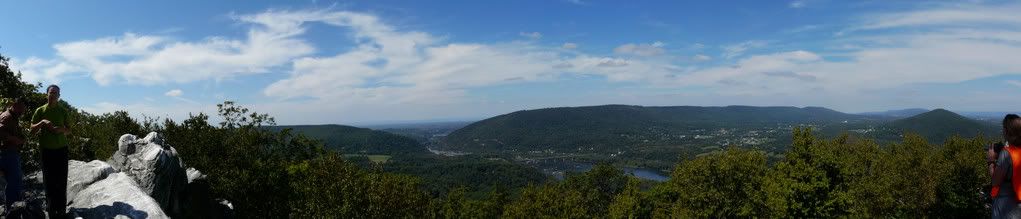
Here is a small slideshow of what you see at the rocky overlook at Point of Rocks, Maryland. The view is of the Potomac.
Charm City Flickr Photowalk
30 photographers took a walk in Fells Point and Canton. Here is my entry.
Charm City Flickr Photowalk.
Widget powered by EveryTrail: GPS GeotaggingDeLorme PN-40, a review

The PN-40 is the latest GPS offered by DeLorme, which is a small mapping company based in Yarmouth, ME. The product was released in early November and many hikers, bikers and geocachers have had the opportunity to purchase it and put it through its paces, including myself.
I could wax poetically about the barometric altimeter and refresh rates, but if you want to know more about those you can go to the DeLorme site and look at the spec page. I've never been that interested in the particulars of these devices. The only thing I care about is whether the GPS can get me to where I need to go. This unit can do it, and do it spectacularly well.
I admit it, I'm a huge map snob. I don't use substandard maps. Maps that I include in the substandard map catagory are: All National Geographic mapping software, PATC maps, Maryland DNR maps and National Park Service maps. For a paper map I will only use National Geographic maps. For mapping software, only DeLorme TOPO will do, period, end of sentence, don't argue with me. I don't have time for incorrect or missing data.
If you read this blog and look at the pictures you will find that I get to places very few other people go. It can take twice as many hours to plan my trip than to carry it out. These bushwhacks I create are complicated, carefully planned and double and triple checked before I leave home. The DeLorme PN-40 is a critical part of the process.
The DeLorme TOPO software allows me to mark-up the basic contour map. I will look at aerial data and create waypoints, outlines of logging roads, identify bridges, parking areas, structures to avoid and fence lines. The aerial data comes from many sources, but I use the black and white aerial data from DeLorme's Netlink server extensively. The black and white pictures are taken in winter and I can see what is on the ground.
I create a draw layer which is an overlay to any map that I view on the PN-40. I transfer the draw layer to the device, and I will also transfer some aerial data, either black & white or color. Once I have everything transferred I create a route that I want to take, and also create some bail-out points just in case.
The PN-40 allows me to create a driving route between my home and the parking area which I have annotated as a waypoint. This way the PN40 works as a road router. Once I get to the trailhead I know that I can pretty much walk anywhere and know exactly where I am. I can change my course if I want, or expand it because I have all the information. I can look at the contour lines, the aerial data, the USGS data, view my intended route, and see my track line.
The PN-40 is lightweight, it only takes 2 AA batteries. It can also use a CRV3 Lithium ion battery pack, which is extremely light and works in very cold temperatures. These batteries are rechargeable and last about 6 hours on a charge while in full routing use. The backlight works well too, in full sun I can see every detail. The device can find addresses and provide phone numbers of "Points of Interest". I've already used it to find a specific cafe and a rental car place.
As far as geocaching goes, I use PN-40 for that too. It works well, I can find the caches without a problem and with the aerial data I have a very good idea where the cache is before I even get to the location. The biggest problem I have now with caches is lousy coordinates provided by cache owners.
The best part of all of this is the cost. You can find the PN-40 now on the J&R site for $340. Most everything you need is included. The mapping software comes with the product. For an extra $30 you can get an unlimited subscription to Netlink for one year. And if you are angry, mad and want to vent can do that too by joining the DeLorme forum. You can ask any questions about the products, make suggestions or provide a tip and someone will provide a response. Try doing that with Magellan or Garmin!
Short Mountain Ridge, The Knob, Virginia

Here is what the view looks like off The Knob at the southern end of Short Mountain Ridge in the Massanuttens, Virginia.
Another East Side Hike
I planned the hike, I organized the hike, I led the hike. The nice thing about the meetup site is you get to showcase other peoples pics. I guess you didn't think I could get any lazier!
St. Mary's College at Patapsco State Park - Ilchester, Maryland
I have no intention of rewriting history, especially when another site has done it so well. For a complete historical perspective of St. Mary's College at the Patapsco State Park, please click here for the StubbornLights write-up. To bring everyone up to date, in February of 2006, the fine State of Maryland mowed down what remains of the main school building because it was one big safety hazard. I can't find anywhere on the Internet to confirm or deny it, but from the looks of the signage around the property, it seems like most of the acreage is now part of our esteemed Patapsco State Park.
Here is my slide show of the way the property looks circa October 2008.


Here is my slide show of the way the property looks circa October 2008.
Southwest Area Park Map and Picturess of Herons- Baltimore County, Maryland
This little unpretentious park is one of my favorites. A boat ramp, a pond and an airport for tiny little planes. What's not to love?
View Southwest Area Park in a larger map


View Southwest Area Park in a larger map


Cotonou - Used cars galore fresh from the Port of Baltimore
 Once again I am crossing the railroad bridge on the way to the fort that overlooks the Locust Point terminals and there is a sea of gently used cars that are lined up pointing toward the water, which is a clear indication they are outbound. Normally, here at the Port of Baltimore storage lots the cars are incoming and new. This particular lot at Locust Point has been utilized most recently for the import of Kia Minivans and compact cars and before that was the big windmill pieces. But now we have these used cars and bunches of them have the word "Cotonou" written on the back windshield. Being a curious person I did some research on what was going on.
Cotonou is the economic capitol of Benin. That is what Wikipedia told me, which was pretty much telling me nothing. I didn't know where Benin was, so I had to click on that too. It turns out Benin is in West Africa. Now, don't think I'm stupid, when I was in the 7th grade I had a social studies teacher that made me memorize all the countries in Africa. The problem was that was about 35 years ago and much has changed, changed in Africa not necessarily my brain content. Anyway, all I can gather was that there used to be these countries called Ivory Coast and Gold Coast and maybe Benin is one of them.
They speak French in Benin and they have about 7 million people. They also have one of the highest infant mortality rates in Benin and only 30% of the population gets adequate healthcare, according to sites on the Internet. The economic engine of Benin is subsistance agriculture. I can't imagine that these poor 7 million people are in desperate need of all our used Lexuses, Toyotas and Hondas. So I did more reading.
We learn there is a port there called the Autonomous Port of Cotonou. We learn this port is filled with corruption.
"The Autonomous Port of Cotonou –- a key gateway to the Benin market for any U.S. businessperson – is a good example of how corruption and static attitudes dampen Benin’s longer-term growth potential. The port serves as a gateway for the sub-region with many goods arriving in Cotonou destined for Nigeria, Burkina Faso, Niger and other countries in West Africa. It is a transshipment point for about 350,000 used cars annually –- 90% of which are re-exported. "
Ah, the mere fact that Nigeria is a bosom buddy neighbor to Benin gave us a clue that things probably weren't so copacetic out there in Cotonou. A few paragraphs down from the same article we learn:
 "Benin’s growth is heavily dependent on the "two pillars" of the country’s economy: trade with Nigeria, and cotton. Lagos’ population of 15 million –- more than double the total population of Benin –- is only 100 kilometers away from Cotonou. Beninese entrepreneurs profit from smuggling and re-exporting products on which Nigeria has imposed import duties or restrictions. The most profitable business in Nigeria for Beninese is in used cars."
I guess those cars are going to end up in Nigeria one way or another. Small wonder that the Beninis pick the fine port of Baltimore with which to do business. I wish those cars well in their trip to Africa.
Here is a google map of the port of Cotonou in case you are wondering what it looks like.
View Larger Map
Where is Benin?
View Port of Cotonou, Benin in a larger map
Short Hill Mountain, Virginia
I would never advocate trespassing. Private property should always be respected. If you were to go to Short Hill Mountain in Virginia this is what hypothetically you might see. The first photo is courtesy of Alexey.


Tubing on the Gunpowder, York Road to Big Falls Road, Maryland
All you need to know about tubing this area of the mighty Gunpowder River. Take a virtual tube down the river.
Gas is 4 bucks a gallon, money is getting tight and Baltimore area residents are desperate for an activity that won't cost an arm and a leg. So without further ado, let's talk about the section of the Gunpowder between York Road and Big Falls Road. This time I chose to potentially sacrifice a camera to get some tubing video, see how much I love you all!
Every time I tube down the Gunpowder I always think the section I have just completed is the nicest, and this time was no different. The segment from York Road to Big Falls proved to have steady water flow, constant movement that didn't require any hand paddling, and incredible scenic beauty. The area is absolutely lush with plant life and all sorts of birds. Rock formations abound. The best part of the segment is that it has trails on both sides that will get you back to your car on York Road. I am not a big fan of carrying an inflated tube, nor do I like to huff and puff my tube once I get to the put-in, so I like to inflate the tube at the car with a little car inflator, tube the river, deflate the tube and civilly walk back to the start. But you can do it any way you wish.
Another tuber admired my tube and asked where I purchased it. I bought my tube for $20 on sale over at Dick's Sporting Goods at the Hunt Valley Mall behind the Wal-Mart. If you don't wish to purchase a tube, you can rent one at Bike Stuff for and then deal with driving over to Monkton, renting the tube for $20, and then driving back there to return it, all the while being wary of their hours of operation. Whatever floats your boat.
Directions to get there: Take I-83 to Exit 27, Hereford - Mt. Carmel Road. Head east on Mt. Carmel Road to York Road. Head north/left on York Road. Drive 2 miles until you get to the parking area at Gunpowder State Park off of York Road.
Below is a map of the area.
View Gunpowder - York Road parking area in a larger map
Early in the morning in the big bad city
Wake-up activities for Osprey and Night Heron in downtown Baltimore.
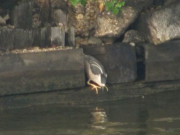
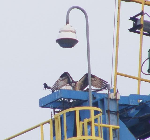


Birds of Springtime.....
...and I am not talking about baseball either. Horned Grebe, Great White Heron, Yellow Crowned Night Heron, Big Blue Heron, Osprey, Loon, Wood Duck, Cormorant, all in Baltimore City.
Indian Springs Wildlife Management Area bushwhack, Maryland
Indian Springs Wildlife Management Area is a state run area set aside supposedly for wildlife management. It is northwest of Hagerstown, MD. This is an extremely quiet area near the Pennsylvania border. I've never paid much attention to it since the mountains aren't all that high. But the area intrigued me and the nice lady at the WMA DNR office sent me some crudely drawn paper maps of the area. I converted some of the hiking trail information onto a good contour map and added some information that I took from aerial data on Google Earth and then added some more information that I gleaned when I hiked Cross, Hearthstone and Sword Mountains this weekend. Here is a good map with good information that anyone can use. I've included some geocache locations.
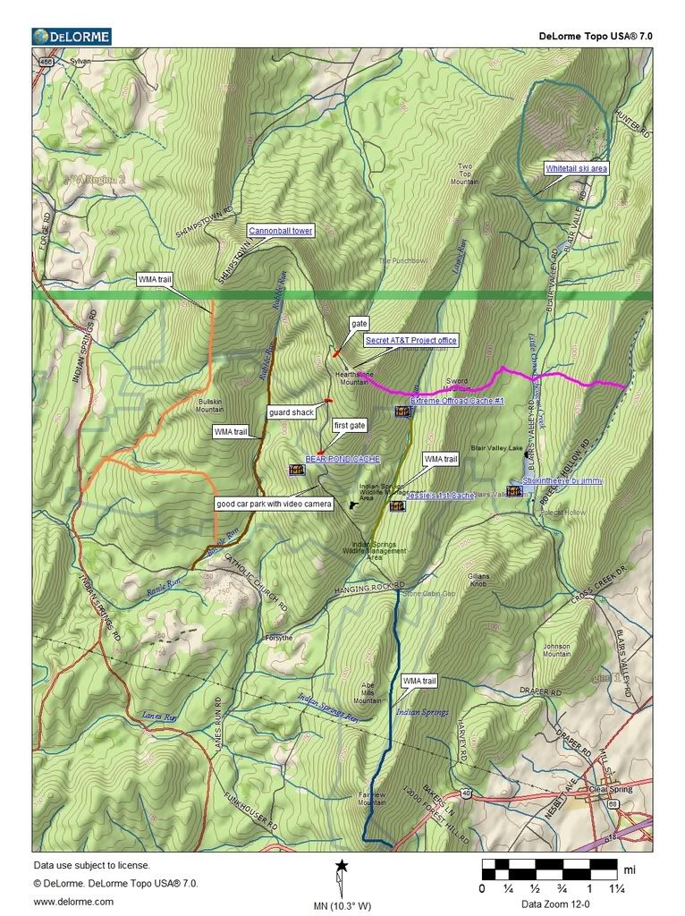
If you want to download a gpx of the Indian Springs WMA border click on the link below:
Since the hiking trails in the area are in extremely poor condition with lots of blowdowns I decided to perform a freeform bushwhack, Keith made the mistake of agreeing to go with me. I had known the Indian Springs WMA was a hotbed of some of the secret underground government installations that pepper the mountains of the Mid-Atlantic area but little did I know that the WMA would be rife with security, gates and video cameras recording our every move. Ominous warning signs about staying away and certain prosecution of all those that dared enter the secured areas would keep even the most hardened souls away, well, except you-know-who.
Security cameras can be both a liability and an asset. They record your every move BUT if you can position your vehicle properly, they can serve as sentry to your vehicle and valuables. We left the car in a position so that thousands of dollars of security camera gear would watch over it, I felt like I was getting something for my homeland security dollar. I was pleased. I decided to teach Keith how to geocache so we actually found 3 geocaches in the area during out backpack, I will post the links for all those that care about this stuff: Bear Pond Cache, Extreme Off Road Cache #1, Jessies 1st Cache. You can see the above map for their locations. Keith was ecstatic, he's a much better geocacher and has more patience with it than me. We bushwhacked around the AT&T gates and guard shacks along the road and tried to stay on state property as much as possible. The AT&T Project Office on Hearthstone Mountain is not what it says it is. It is actually some sort of top secret underground government FEMA bunker type thing. Some Internet sites say it is abandoned but I doubt it is considering I found that all the aerial data available shows cars in the parking lot and the place very well maintained. You can poke around this site to learn more about all the secret underground government installations that ring the Mid-Atlantic. I seem to always be running into them, I've stumbled across many during my hikes.
Keith and I bushwhacked northward and came upon a turtle and a snake. Once we got into a clearing we looked up and say a huge concrete tower on Cross Mountain. Naturally we were interested in knowing what it was so we scrambled up to the top of the ridge and followed the Shimpstown Road at the top to find that it was a 103 foot Site 2 Cannonball tower that had something to do with microwaves during the cold war. It was pretty cool.
I had thought we might be able to bushwhack down into the Punchbowl in Pennsylvania but it was a bit overgrown so late in the spring so we were forced to do something very dangerous. We went east over to the AT&T Project office and started to bushwhack along it's northern perimeter which turned out to be an incredibly steep slope filled with talus and blowdowns. We decided to hug the fence and get over to the east side of the Project Office. At this point we didn't care who was surveying us. We waved at the cameras, no helicopter came so I guess we didn't look like terrorists to whomever was watching.
We then got to where some underground gas lines headed eastward off of Hearthstone Mountain and an another incredibly steep slope. Keith and I both were in need of water so we had no choice but to descend. I would say we did a drop of 1500 feet in less than a mile. We were both lucky we didn't fall. We rehydrated and headed further eastward up to the gas line clearing on top of Sword mountain and camped for the night, we had a good fire and a good view.
In the morning our plan was to bushwhack along the Sword Mountain ridge to the road southward but the ridge was incredibly rocky so we had no choice but go back to Lanes Run and then we found another couple of geocaches. Once we got to Shimpstown Road to the south we had to go back uphill to get to the car. The track line looked like this:
The hike profile looked like:

So this 14.2 brutal bushwhack included 4877 feet of elevation change, most of that was performed off-trail under absolutely miserable surface conditions. If you think you are a hiking pro I challenge you to come to lowly Maryland and play a bit on the granite talus, you'll be humbled real quick.
Here is the slideshow of the hike:
Update 11/5/2010 So many people have been hitting this blog post obviously looking for a map of Indian Springs WMA to use for hunting season. This post was up in the days prior to Google Maps. So I took some of the information that I prepared above and placed it on a Google Map that might come in handy for those who have iPhones, Droids, Blackberries and other types of GPS enabled phones. Here you go, enjoy:
View Indian Springs Border and Trail Map in on the Google Maps page to save to "My Maps" to use with your phone

If you want to download a gpx of the Indian Springs WMA border click on the link below:
Indian Springs WMA border as gpx, Maryland
Widget powered by EveryTrail: GPS GeotaggingSince the hiking trails in the area are in extremely poor condition with lots of blowdowns I decided to perform a freeform bushwhack, Keith made the mistake of agreeing to go with me. I had known the Indian Springs WMA was a hotbed of some of the secret underground government installations that pepper the mountains of the Mid-Atlantic area but little did I know that the WMA would be rife with security, gates and video cameras recording our every move. Ominous warning signs about staying away and certain prosecution of all those that dared enter the secured areas would keep even the most hardened souls away, well, except you-know-who.
Security cameras can be both a liability and an asset. They record your every move BUT if you can position your vehicle properly, they can serve as sentry to your vehicle and valuables. We left the car in a position so that thousands of dollars of security camera gear would watch over it, I felt like I was getting something for my homeland security dollar. I was pleased. I decided to teach Keith how to geocache so we actually found 3 geocaches in the area during out backpack, I will post the links for all those that care about this stuff: Bear Pond Cache, Extreme Off Road Cache #1, Jessies 1st Cache. You can see the above map for their locations. Keith was ecstatic, he's a much better geocacher and has more patience with it than me. We bushwhacked around the AT&T gates and guard shacks along the road and tried to stay on state property as much as possible. The AT&T Project Office on Hearthstone Mountain is not what it says it is. It is actually some sort of top secret underground government FEMA bunker type thing. Some Internet sites say it is abandoned but I doubt it is considering I found that all the aerial data available shows cars in the parking lot and the place very well maintained. You can poke around this site to learn more about all the secret underground government installations that ring the Mid-Atlantic. I seem to always be running into them, I've stumbled across many during my hikes.
Keith and I bushwhacked northward and came upon a turtle and a snake. Once we got into a clearing we looked up and say a huge concrete tower on Cross Mountain. Naturally we were interested in knowing what it was so we scrambled up to the top of the ridge and followed the Shimpstown Road at the top to find that it was a 103 foot Site 2 Cannonball tower that had something to do with microwaves during the cold war. It was pretty cool.
I had thought we might be able to bushwhack down into the Punchbowl in Pennsylvania but it was a bit overgrown so late in the spring so we were forced to do something very dangerous. We went east over to the AT&T Project office and started to bushwhack along it's northern perimeter which turned out to be an incredibly steep slope filled with talus and blowdowns. We decided to hug the fence and get over to the east side of the Project Office. At this point we didn't care who was surveying us. We waved at the cameras, no helicopter came so I guess we didn't look like terrorists to whomever was watching.
We then got to where some underground gas lines headed eastward off of Hearthstone Mountain and an another incredibly steep slope. Keith and I both were in need of water so we had no choice but to descend. I would say we did a drop of 1500 feet in less than a mile. We were both lucky we didn't fall. We rehydrated and headed further eastward up to the gas line clearing on top of Sword mountain and camped for the night, we had a good fire and a good view.
In the morning our plan was to bushwhack along the Sword Mountain ridge to the road southward but the ridge was incredibly rocky so we had no choice but go back to Lanes Run and then we found another couple of geocaches. Once we got to Shimpstown Road to the south we had to go back uphill to get to the car. The track line looked like this:

The hike profile looked like:

So this 14.2 brutal bushwhack included 4877 feet of elevation change, most of that was performed off-trail under absolutely miserable surface conditions. If you think you are a hiking pro I challenge you to come to lowly Maryland and play a bit on the granite talus, you'll be humbled real quick.
Here is the slideshow of the hike:
Update 11/5/2010 So many people have been hitting this blog post obviously looking for a map of Indian Springs WMA to use for hunting season. This post was up in the days prior to Google Maps. So I took some of the information that I prepared above and placed it on a Google Map that might come in handy for those who have iPhones, Droids, Blackberries and other types of GPS enabled phones. Here you go, enjoy:
View Indian Springs Border and Trail Map in on the Google Maps page to save to "My Maps" to use with your phone
Panoramio, a strange obsession

Google Earth has been very good to me. The site has been incredibly helpful in planning my many bushwhacks and hikes for the last couple of years. A little over a year and half ago I noticed all sorts of little blue dots showing up on the GE map, signifying images people have taken of various spots on the aerial data and uploaded to Panoramio as an optional layer. I looked at the images available for my beautiful city and noticed that the Inner Harbor had become ground zero for Baltimore City Panoramio pictures but not much had been submitted for the rest of my fair city. So, using my neighbor's lightening speed wifi connection, I perused my picture directory and placed as many images I could of the city and elsewhere with my photos, primarily taken with my cheap camera.
I was pretty pleased with the result and was further enthused when I found I could monitor the count of pictures viewed. Unfortunately, 2 weeks after I had uploaded my first group of photos I received a rather unnerving comment about this picture.
 Now, I had deleted the comment in disgust but it went something like this:
"I can't believe that you would put up such an ugly picture of a bunch of ugly houses in Pottsville, PA when there are so many other nicer buildings to photograph."
You could just imagine the steam that was coming out of my ears when I read that. I didn't think those rowhomes were ugly at all. I think they are beautiful. I think rowhomes are beautiful. I live in a rowhome. I am pleased to announce that even though I deleted that nasty comment, the Pottsville rowhome picture is my most popular photo. 440 wonderful people have looked at the rowhomes in Pottsville. Other pictures that people seem to like are the one I took of Orianda and one of Antietam.
Photos that I like the best rarely get viewed, those that I don't think are so great are incredibly popular. I can't explain taste. I have learned I have a strange affinity for domes on churches, the strange way Baltimore City cleans the trash out of the harbor, tulips, herons and bears. I have too many pictures of mountains and maybe too few of people.
Maybe the one thing I have learned is that I see the world in a much stranger way than everyone else.


Subscribe to:
Posts (Atom)