
Masonville Cove, Baltimore Maryland, Explanation and Map
Update: There seems to be flurry of activity with people searching for where Masonville Cove is, so out of the goodness of my heart I am giving you a Google Map. Have at it.
View Larger Map
Now back to our regularly scheduled program:
It all started so innocently enough. Those pretty yellow city recycle bins were popping up in front of my yuppie neighbors houses like rat feces. I had to have one. So with a little research I found that this organization over in Brooklyn had them for sale. So one day I went over there to purchase my bin and the lady at the center gave me some sort of promotional calender touting the wonders of their organization. Immediately I was skeptical, always distrust anyone you don't know bearing gifts. The calendar outlined some helpful hints on how to effectively "go green", a matter I am sure that is pressing for the crack dealers, meth heads and prostitutes that seem to occupy every corner of Brooklyn Park. I looked closer at the calendar, it was sponsored(i.e., paid for) by the Maryland Port Administration.
Immediately, I smelled trouble.
Why would the Maryland Port Administration be subsidizing free calendars for a nonprofit on the outskirts of Baltimore City? Inquiring minds want to know. It didn't take much to find out why. It's time for the unwashed masses to learn a new word for the day, "dredge" so I can connect the dots for all of you. You see, Maryland has a very big big business called the Port. The port deals with lots of big big ships that bring lots of stuff to the city. The ports is a big distribution point for lots of cheap crap that the US imports from China. In order to get those big big ships into the port the Maryland Port Administration (MPA) have to dig a big trench in the bottom of the bay. When you dig a big trench you end up with lots of mud, silt, sand, clay and stinky stuff, called dredge, that has to be put somewhere. In the past the MPA was putting the dredge in a place called Hart Miller Island up in Baltimore County. Things were going well, the island was getting bigger, lots of birds liked the island. Unfortunately, for Hart Miller Island, the area around it got surrounded by lots of rich people who didn't like to look at all that ugly dredge.
The MPA needed a new place to put their stinky dredge. They didn't want to put the dredge in front of rich people's waterfront homes because they knew the rich people would complain. What the MPA needed was a place where poor people lived, people that didn't vote, people that didn't pay too many taxes, a place where people would not complain about the dredge pile or how big it got or how bad it smelled. The MPA knew just where to go, where there was an unlimited supply of crack dealers, meth heads and prostitutes. Welcome to Brooklyn, Maryland.
But even the people of Brooklyn were hesitant. They tried to complain, tried to raise a ruckus, but the state was loud and powerful. To make it all better for little Brooklyn the state threw Brooklyn a little bone. On top of all the stinking dredge the state is to make a little park and a little environmental center. Oh, goody! Also, they get an unlimited supply of free calendars.
After perusing my new calendar I asked the lady over at the Brooklyn and Curtis Bay Coalition whether it was possible to visit Masonville Cove now. She said, "No, you can't go there."
I didn't think I heard her correctly so I said, "But you are going to build a park eventually, why can't I go there now?"
She replied very loudly, "No, you can't go there."
So I asked again, "Surely, there must be a way to get to Masonville Cove now."
She screamed, "YOU CAN'T GO THERE!"
So naturally I had to go visit Masonville Cove immediately.
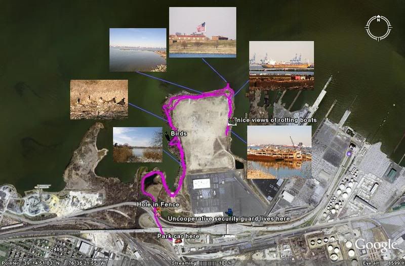
Camera, GPS, hiking boots, you know the drill. It wasn't long before I had a track line (not that kind of track line, silly, a GPS track line) and a some pics. The place stinks to high heaven. I feel sorry for the Brooklyn crack-heads, if Masonville Cove stinks in February just imagine what it is going to smell like August. Here is the exciting slide show.


Update #2 October 2010 - I returned to Masonville Cove recently and wrote a new post about the area.
View Larger Map
Now back to our regularly scheduled program:

It all started so innocently enough. Those pretty yellow city recycle bins were popping up in front of my yuppie neighbors houses like rat feces. I had to have one. So with a little research I found that this organization over in Brooklyn had them for sale. So one day I went over there to purchase my bin and the lady at the center gave me some sort of promotional calender touting the wonders of their organization. Immediately I was skeptical, always distrust anyone you don't know bearing gifts. The calendar outlined some helpful hints on how to effectively "go green", a matter I am sure that is pressing for the crack dealers, meth heads and prostitutes that seem to occupy every corner of Brooklyn Park. I looked closer at the calendar, it was sponsored(i.e., paid for) by the Maryland Port Administration.
Immediately, I smelled trouble.
Why would the Maryland Port Administration be subsidizing free calendars for a nonprofit on the outskirts of Baltimore City? Inquiring minds want to know. It didn't take much to find out why. It's time for the unwashed masses to learn a new word for the day, "dredge" so I can connect the dots for all of you. You see, Maryland has a very big big business called the Port. The port deals with lots of big big ships that bring lots of stuff to the city. The ports is a big distribution point for lots of cheap crap that the US imports from China. In order to get those big big ships into the port the Maryland Port Administration (MPA) have to dig a big trench in the bottom of the bay. When you dig a big trench you end up with lots of mud, silt, sand, clay and stinky stuff, called dredge, that has to be put somewhere. In the past the MPA was putting the dredge in a place called Hart Miller Island up in Baltimore County. Things were going well, the island was getting bigger, lots of birds liked the island. Unfortunately, for Hart Miller Island, the area around it got surrounded by lots of rich people who didn't like to look at all that ugly dredge.
The MPA needed a new place to put their stinky dredge. They didn't want to put the dredge in front of rich people's waterfront homes because they knew the rich people would complain. What the MPA needed was a place where poor people lived, people that didn't vote, people that didn't pay too many taxes, a place where people would not complain about the dredge pile or how big it got or how bad it smelled. The MPA knew just where to go, where there was an unlimited supply of crack dealers, meth heads and prostitutes. Welcome to Brooklyn, Maryland.
But even the people of Brooklyn were hesitant. They tried to complain, tried to raise a ruckus, but the state was loud and powerful. To make it all better for little Brooklyn the state threw Brooklyn a little bone. On top of all the stinking dredge the state is to make a little park and a little environmental center. Oh, goody! Also, they get an unlimited supply of free calendars.
After perusing my new calendar I asked the lady over at the Brooklyn and Curtis Bay Coalition whether it was possible to visit Masonville Cove now. She said, "No, you can't go there."
I didn't think I heard her correctly so I said, "But you are going to build a park eventually, why can't I go there now?"
She replied very loudly, "No, you can't go there."
So I asked again, "Surely, there must be a way to get to Masonville Cove now."
She screamed, "YOU CAN'T GO THERE!"
So naturally I had to go visit Masonville Cove immediately.
Camera, GPS, hiking boots, you know the drill. It wasn't long before I had a track line (not that kind of track line, silly, a GPS track line) and a some pics. The place stinks to high heaven. I feel sorry for the Brooklyn crack-heads, if Masonville Cove stinks in February just imagine what it is going to smell like August. Here is the exciting slide show.
Update #2 October 2010 - I returned to Masonville Cove recently and wrote a new post about the area.


Woodmont Rod and Gun Club Map, Directions and Open House Schedule

Back in 1995 the property of the Woodmont Rod and Gun Club, aka Woodmont Natural Resource Management Area, near Sideling Hill WMA was transferred over to the fine State of Maryland. The State, never one to invest funds into parks, recreation, forests and such, promptly handed to property to this organization, The Izaak Walton League of America to "manage" the property. The state holds an open house twice a year so us commoners can get a looksee into the place.
The 2009 Open House Schedule for the Woodmont Rod and Gun Club is:
Saturday May 9, 2008 hours 10-3
Saturday September 19, 2008 hours 10-3
There is no entrance fee
Here are the directions to the facility:
Take I-68 to Woodmont Exit 77, continue on Woodmont Road for 5 miles south and watch for the red signs for the Woodmont Lodge. The lodge is located at 11761 Woodmont Road.
View Larger Map
Even though the state still owns the Woodmont property, there is no available map of it on the Internet. The fine state of Maryland has provided me with a couple of paper maps of Woodmont, I have also referred to the DNR Sideling Hill Map. All the maps are different. I have taken the liberty of creating my own map of the Woodmont property, this was hand drawn by me to the best of my abilities. Feel free to use it.
Update 11/07/10 I see a lot of hits on this particular post of people trying to find out the location of the Woodmont Rod and Gun Club. I've also received some updated mapping software that actually has the border of the Sideling Hill WMA on it. So I figured somebody might be interested in an accurate Google Map of the WMA. This should be transferable to your Smartphone if you know how to work with Google Maps.
View Woodmont Rod and Gun Club in Google Maps so you can transfer the maps to your "My Maps" page.
Subscribe to:
Posts (Atom)