My new beaver friend at Loch Raven


The little forest creatures seem to like me. I don't really know why. I was at Loch Raven and I came upon a beaver. First, beaver wasn't too impressed, he splashed me several times with his tail and the water was cold. I chatted with him and then he decided to follow me along the shore. I sat down and he got out of the water and started to itch. I guess beavers spend a great deal of time itching. I made a short video of the itching beaver.


Here is the slideshow of beaver and some other stuff I saw.

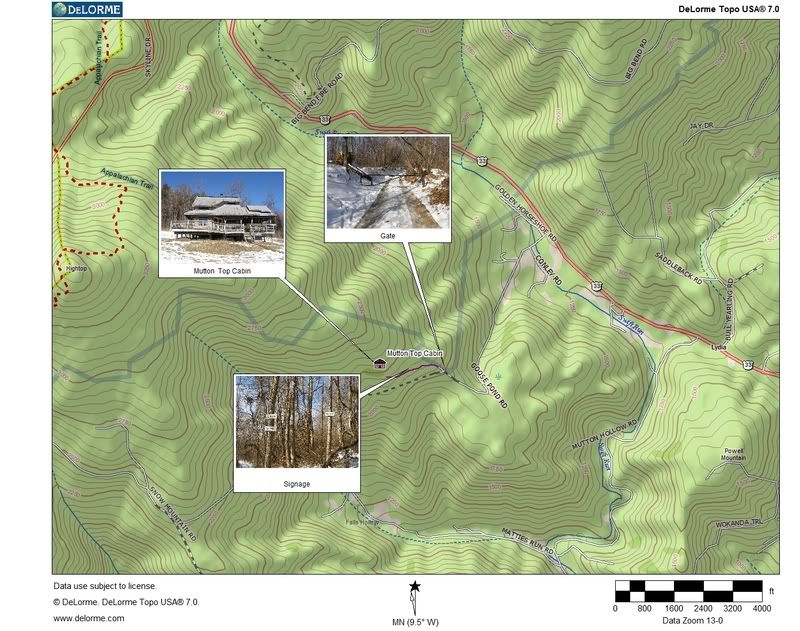
Directions to Mutton Top Cabin, map;Mutton Top Cabin Weekend

For anyone that wants to know how to get to Mutton Top Cabin, here is a printable paper map with pictures:
Map to Mutton Top

Here is a Google Map:

View Mutton Top Cabin in a larger map

Directions:
Go to Stanardsville, VA. Take Route 33 West for 6 miles. Take a left on Goose Pond Road. Drive 1.5 miles until you see a gate. Park your car. Pass gate and walk .5 miles on the road until you see the cabin.

Our fun:

Keith invited several of his friends for a cabin weekend at a PATC cabin called Mutton Top. About 15 people from PATC Cadillac Crew, HoCo Sierra Club and MCOM. There was significant snow cover on the mountain making the Vining Tract, where the cabin was located, very beautiful. I organized a bushwhack/hike from the cabin to the AT and along some roads. Keith, James, Lisa and myself used the PN20 GPS to get from the cabin to the AT and then down some roads. It was a lot of work to figure out where we needed to go to get up on the ridge but once I had everything planned the hike went very well. We found some coyote and bear prints in the snow, as well as some bear hair left on a fence. Keith found the bear den and wanted to say hello to the bear but I strongly suggested we move along, I want to wait a bit to have my inevitable first bear interaction for 2008.

Everyone left on Sunday and I opted to stay another day to close up the cabin. When I woke up this morning, Monday, it was 0 degrees in the cabin and the olive oil froze. In the slideshow I have some pictures to prove I cleaned that cabin spic and span. Keith did a great job with the organization of the weekend and a very good time was had by all.

More fun with the camera and GPS

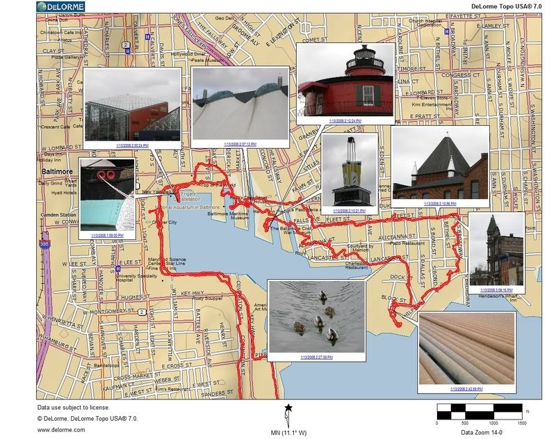
I'm incapable of walking in a straight line

Inner Harbor track and pics


You have to love a town that is smart enough to spend money to tenderly take care of a historic sewage pump station. My tax dollars spent very wisely, love that building.


SBER should learn to lock their gate.

The American Brewery - End to a great era

What are they doing to my brewery? Horrors upon horrors, the Struever team is screwing with my building. I went on the the Sun site and was treated to this nightmarish picture:


Let's discuss the history here, no not the 'this was once a brewery history', the recent history with this building. When I first moved here the movie "Tin Men" turned up in theaters, and the last scene of this movie featured a shot of this building in the distance. It became my mission to find it. Back then there was no Internet but somehow somewhere someone turned me on to its location. The American Brewery is an architectural marvel. The best thing about it is its location. There is no worse location anywhere for anything than in the 1700 block of Gay Street. Baghdad, Kabul and Berlin during the siege are in better shape. Think the Alamo or Murder at the OK Corral.

The fine city of Baltimore desperately wanted somebody to take this place on, sink some money into it and save it. But developers are all about earning money, which means they would need a buyer or a renter once they got done and absolutely nobody nowhere is going to want to venture into this hood, not during the night, not during the day, not at high noon. As the city argued with developers and begged the state for some sort of tax relief for the project, this wonderful building sat idle and untouched, a wonderful refuge from the rehabilitation assault that is currently in place on every warehouse, B-rated office building and row house towne home that exists in my beautiful city.

But the machinations of government was moving forward behind the scenes. They got all the usual suspects together, Bill Struever to build it, Diane Cho to design it, but the very best juiciest part of this story is that somebody conned some goody-two-shoes outfit to move in. The current address of the do-gooders is off of Broken Land Parkway in that bland nowhereville called Columbia. Here is a picture of Humanim's current offices in plush Howard County:


Here is an aerial picture of Humanim's future home:


People, I can't tell how good this is going to get when Humanim tries to convince their workerbees to relocate. I envision an suburban office full of young hip ratdogs. What is a ratdog? It is a little term I have cooked up for spoiled young white women armed with a college education and an office job. The one thing that terrifies the ratdogs the most is big black negroes, and this neighborhood is filled with lots of big black negroes. Is Humanim going to provide vehicle escort service for their workers? Where are these ratdogs going to find a Starbucks in this hood? A gym? Nail salon?

I know this hood well. There are a few places nearby where you can get your car detailed, and get a great deal on a used appliance. If you are too lazy to visit the pharmacy for your prescription meds, boy, is this the place for you! The locals are willing to deliver and you don't have to pay market rates.

Me? I'd be thrilled and honored to be able to work on the East Side. I could get a decent serving of lake trout for lunch and get a fantastic wash and wax for my minivan, plus this hood is unparalleled when it comes to urban hiking. But I don't think those rat dogs eat lake trout so be sure to stay tuned for January 2009 when Humanim does the relo, I certainly will.

Updated 06/24/12 Did I actually write that back in 2008? What a difference a few years makes. Tonight I had a meeting at the Humanim offices and I grabbed my camera. I took a lot of pictures and developed this slide show to show you what the inside of the American Brewery looks like. It's actually quite pleasant, and I liked they way they paid homage to what was there before. I'll assume by this time most of the old Columbia Humanim team has been replace by more-appropriate city dwellers.

Gunpowder Trail Bushwhack

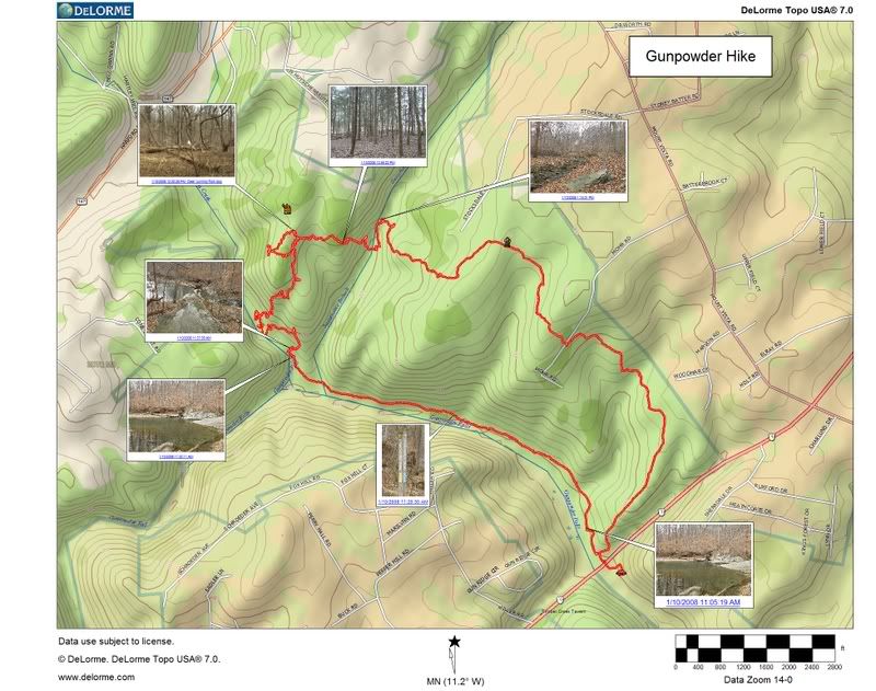
Really people, I need to seriously get a life. I used Earthmate Image Tagger which is some free software from DeLorme to coordinate my DeLorme Earthmate GPS PN-20 GPS Data with pictures taken with my Olympus SP-550 UZ camera. The result is thumbnails placed at the exact location of my hike using DeLorme TOPO 7.0 mapping software.

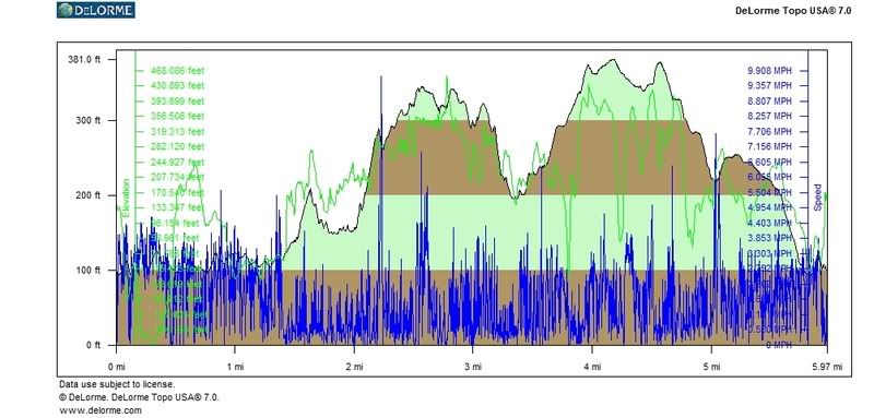
I have attached the profile generated from the tracks off the GPS. Perhaps this is all TMI.

Gunpowder Map with pics and tracks
Gunpowder Profile

There is a way to coordinate a HRM, but there has to be a point where all this insanity must stop. Enough already.

Dans Mountain, Maryland and Piedmont, WV

As you all know by know I have had it up to my eyeballs with PATC maintained trails. So I went looking for new vistas and decided that Dans Mountain in Western Maryland shall be explored via a bushwhack. I set my sights on going from the overlook at the northern tip and head on the ridge as much as possible to the southern tip near Westernport. The only taker for this adventure extravaganza was Keith.

Things went pretty well for the first couple of miles. We started at the Dans Mountain Overlook, we found a nice bubba trail to Wolf rock and then were able to follow some wildlife trails for another mile or two. But things got really rough due to the damage from an ice storm a few years back, the same storm that made things hellacious up at the Big Savage ridge last year. So we bushwhacked east down the steep ridge to the road and then went back up the ridge at the power lines. There are some logging roads/DNR roads up there that crisscross in that area so one could have some fun without too much trouble near the southern trip of the ridge. One can access this area from the convergence of Stoney Run Road and Pond Hill Road. The people in those hills are very nice and friendly. This entire extravaganza took 2 full days so take a backpack if you wish to go from one end to another via some bushwhack. I saw bear tracks and one herd of white tail so there is a lot of good wildlife. I'd stay out of this area in warm temps because there is a great deal of loose talus and the area is a hotbed for rattlers. New Years eve was quite the party in the valley, we saw lots of fireworks from our camp and heard a great deal of gun and rifle shots. Hunting season had wrapped up on Saturday so I guess people were blowing off unused ammo.

After our backpack, Keith and I took some time out to visit Piedmont, WV. Now I remind you that I live in a ghetto, but this place takes the cake when it comes to squalor. I can't figure out why Westernport, MD looks so nice and economically healthy and Piedmont, WV which is only a 50 ft. bridge away looks so god awful. If anyone can clue me in I'd be much obliged. Here is my Piedmont, WV slide show.


I also hear through the grapevine that the PATC is a tad upset with me regarding one of my Youtube videos. I would like to convey my heartfelt sympathy for the way they feel and also tell them that there will be a snowball's chance in hell that the video will be removed.