

Tubing on the Gunpowder, York Road to Big Falls Road, Maryland
All you need to know about tubing this area of the mighty Gunpowder River. Take a virtual tube down the river.
Gas is 4 bucks a gallon, money is getting tight and Baltimore area residents are desperate for an activity that won't cost an arm and a leg. So without further ado, let's talk about the section of the Gunpowder between York Road and Big Falls Road. This time I chose to potentially sacrifice a camera to get some tubing video, see how much I love you all!
Every time I tube down the Gunpowder I always think the section I have just completed is the nicest, and this time was no different. The segment from York Road to Big Falls proved to have steady water flow, constant movement that didn't require any hand paddling, and incredible scenic beauty. The area is absolutely lush with plant life and all sorts of birds. Rock formations abound. The best part of the segment is that it has trails on both sides that will get you back to your car on York Road. I am not a big fan of carrying an inflated tube, nor do I like to huff and puff my tube once I get to the put-in, so I like to inflate the tube at the car with a little car inflator, tube the river, deflate the tube and civilly walk back to the start. But you can do it any way you wish.
Another tuber admired my tube and asked where I purchased it. I bought my tube for $20 on sale over at Dick's Sporting Goods at the Hunt Valley Mall behind the Wal-Mart. If you don't wish to purchase a tube, you can rent one at Bike Stuff for and then deal with driving over to Monkton, renting the tube for $20, and then driving back there to return it, all the while being wary of their hours of operation. Whatever floats your boat.


Directions to get there: Take I-83 to Exit 27, Hereford - Mt. Carmel Road. Head east on Mt. Carmel Road to York Road. Head north/left on York Road. Drive 2 miles until you get to the parking area at Gunpowder State Park off of York Road.
Below is a map of the area.
View Gunpowder - York Road parking area in a larger map
Gas is 4 bucks a gallon, money is getting tight and Baltimore area residents are desperate for an activity that won't cost an arm and a leg. So without further ado, let's talk about the section of the Gunpowder between York Road and Big Falls Road. This time I chose to potentially sacrifice a camera to get some tubing video, see how much I love you all!
Every time I tube down the Gunpowder I always think the section I have just completed is the nicest, and this time was no different. The segment from York Road to Big Falls proved to have steady water flow, constant movement that didn't require any hand paddling, and incredible scenic beauty. The area is absolutely lush with plant life and all sorts of birds. Rock formations abound. The best part of the segment is that it has trails on both sides that will get you back to your car on York Road. I am not a big fan of carrying an inflated tube, nor do I like to huff and puff my tube once I get to the put-in, so I like to inflate the tube at the car with a little car inflator, tube the river, deflate the tube and civilly walk back to the start. But you can do it any way you wish.
Another tuber admired my tube and asked where I purchased it. I bought my tube for $20 on sale over at Dick's Sporting Goods at the Hunt Valley Mall behind the Wal-Mart. If you don't wish to purchase a tube, you can rent one at Bike Stuff for and then deal with driving over to Monkton, renting the tube for $20, and then driving back there to return it, all the while being wary of their hours of operation. Whatever floats your boat.
Directions to get there: Take I-83 to Exit 27, Hereford - Mt. Carmel Road. Head east on Mt. Carmel Road to York Road. Head north/left on York Road. Drive 2 miles until you get to the parking area at Gunpowder State Park off of York Road.
Below is a map of the area.
View Gunpowder - York Road parking area in a larger map
Early in the morning in the big bad city
Wake-up activities for Osprey and Night Heron in downtown Baltimore.
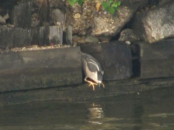
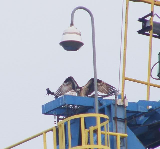


Birds of Springtime.....
...and I am not talking about baseball either. Horned Grebe, Great White Heron, Yellow Crowned Night Heron, Big Blue Heron, Osprey, Loon, Wood Duck, Cormorant, all in Baltimore City.
Indian Springs Wildlife Management Area bushwhack, Maryland
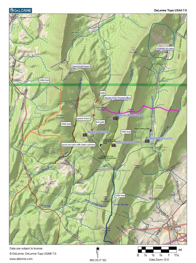
Indian Springs Wildlife Management Area is a state run area set aside supposedly for wildlife management. It is northwest of Hagerstown, MD. This is an extremely quiet area near the Pennsylvania border. I've never paid much attention to it since the mountains aren't all that high. But the area intrigued me and the nice lady at the WMA DNR office sent me some crudely drawn paper maps of the area. I converted some of the hiking trail information onto a good contour map and added some information that I took from aerial data on Google Earth and then added some more information that I gleaned when I hiked Cross, Hearthstone and Sword Mountains this weekend. Here is a good map with good information that anyone can use. I've included some geocache locations.
If you want to download a gpx of the Indian Springs WMA border click on the link below:
Since the hiking trails in the area are in extremely poor condition with lots of blowdowns I decided to perform a freeform bushwhack, Keith made the mistake of agreeing to go with me. I had known the Indian Springs WMA was a hotbed of some of the secret underground government installations that pepper the mountains of the Mid-Atlantic area but little did I know that the WMA would be rife with security, gates and video cameras recording our every move. Ominous warning signs about staying away and certain prosecution of all those that dared enter the secured areas would keep even the most hardened souls away, well, except you-know-who.
Security cameras can be both a liability and an asset. They record your every move BUT if you can position your vehicle properly, they can serve as sentry to your vehicle and valuables. We left the car in a position so that thousands of dollars of security camera gear would watch over it, I felt like I was getting something for my homeland security dollar. I was pleased. I decided to teach Keith how to geocache so we actually found 3 geocaches in the area during out backpack, I will post the links for all those that care about this stuff: Bear Pond Cache, Extreme Off Road Cache #1, Jessies 1st Cache. You can see the above map for their locations. Keith was ecstatic, he's a much better geocacher and has more patience with it than me. We bushwhacked around the AT&T gates and guard shacks along the road and tried to stay on state property as much as possible. The AT&T Project Office on Hearthstone Mountain is not what it says it is. It is actually some sort of top secret underground government FEMA bunker type thing. Some Internet sites say it is abandoned but I doubt it is considering I found that all the aerial data available shows cars in the parking lot and the place very well maintained. You can poke around this site to learn more about all the secret underground government installations that ring the Mid-Atlantic. I seem to always be running into them, I've stumbled across many during my hikes.
Keith and I bushwhacked northward and came upon a turtle and a snake. Once we got into a clearing we looked up and say a huge concrete tower on Cross Mountain. Naturally we were interested in knowing what it was so we scrambled up to the top of the ridge and followed the Shimpstown Road at the top to find that it was a 103 foot Site 2 Cannonball tower that had something to do with microwaves during the cold war. It was pretty cool.
I had thought we might be able to bushwhack down into the Punchbowl in Pennsylvania but it was a bit overgrown so late in the spring so we were forced to do something very dangerous. We went east over to the AT&T Project office and started to bushwhack along it's northern perimeter which turned out to be an incredibly steep slope filled with talus and blowdowns. We decided to hug the fence and get over to the east side of the Project Office. At this point we didn't care who was surveying us. We waved at the cameras, no helicopter came so I guess we didn't look like terrorists to whomever was watching.
We then got to where some underground gas lines headed eastward off of Hearthstone Mountain and an another incredibly steep slope. Keith and I both were in need of water so we had no choice but to descend. I would say we did a drop of 1500 feet in less than a mile. We were both lucky we didn't fall. We rehydrated and headed further eastward up to the gas line clearing on top of Sword mountain and camped for the night, we had a good fire and a good view.
In the morning our plan was to bushwhack along the Sword Mountain ridge to the road southward but the ridge was incredibly rocky so we had no choice but go back to Lanes Run and then we found another couple of geocaches. Once we got to Shimpstown Road to the south we had to go back uphill to get to the car. The track line looked like this:
The hike profile looked like:

So this 14.2 brutal bushwhack included 4877 feet of elevation change, most of that was performed off-trail under absolutely miserable surface conditions. If you think you are a hiking pro I challenge you to come to lowly Maryland and play a bit on the granite talus, you'll be humbled real quick.
Here is the slideshow of the hike:
Update 11/5/2010 So many people have been hitting this blog post obviously looking for a map of Indian Springs WMA to use for hunting season. This post was up in the days prior to Google Maps. So I took some of the information that I prepared above and placed it on a Google Map that might come in handy for those who have iPhones, Droids, Blackberries and other types of GPS enabled phones. Here you go, enjoy:
View Indian Springs Border and Trail Map in on the Google Maps page to save to "My Maps" to use with your phone

If you want to download a gpx of the Indian Springs WMA border click on the link below:
Indian Springs WMA border as gpx, Maryland
Widget powered by EveryTrail: GPS GeotaggingSince the hiking trails in the area are in extremely poor condition with lots of blowdowns I decided to perform a freeform bushwhack, Keith made the mistake of agreeing to go with me. I had known the Indian Springs WMA was a hotbed of some of the secret underground government installations that pepper the mountains of the Mid-Atlantic area but little did I know that the WMA would be rife with security, gates and video cameras recording our every move. Ominous warning signs about staying away and certain prosecution of all those that dared enter the secured areas would keep even the most hardened souls away, well, except you-know-who.
Security cameras can be both a liability and an asset. They record your every move BUT if you can position your vehicle properly, they can serve as sentry to your vehicle and valuables. We left the car in a position so that thousands of dollars of security camera gear would watch over it, I felt like I was getting something for my homeland security dollar. I was pleased. I decided to teach Keith how to geocache so we actually found 3 geocaches in the area during out backpack, I will post the links for all those that care about this stuff: Bear Pond Cache, Extreme Off Road Cache #1, Jessies 1st Cache. You can see the above map for their locations. Keith was ecstatic, he's a much better geocacher and has more patience with it than me. We bushwhacked around the AT&T gates and guard shacks along the road and tried to stay on state property as much as possible. The AT&T Project Office on Hearthstone Mountain is not what it says it is. It is actually some sort of top secret underground government FEMA bunker type thing. Some Internet sites say it is abandoned but I doubt it is considering I found that all the aerial data available shows cars in the parking lot and the place very well maintained. You can poke around this site to learn more about all the secret underground government installations that ring the Mid-Atlantic. I seem to always be running into them, I've stumbled across many during my hikes.
Keith and I bushwhacked northward and came upon a turtle and a snake. Once we got into a clearing we looked up and say a huge concrete tower on Cross Mountain. Naturally we were interested in knowing what it was so we scrambled up to the top of the ridge and followed the Shimpstown Road at the top to find that it was a 103 foot Site 2 Cannonball tower that had something to do with microwaves during the cold war. It was pretty cool.
I had thought we might be able to bushwhack down into the Punchbowl in Pennsylvania but it was a bit overgrown so late in the spring so we were forced to do something very dangerous. We went east over to the AT&T Project office and started to bushwhack along it's northern perimeter which turned out to be an incredibly steep slope filled with talus and blowdowns. We decided to hug the fence and get over to the east side of the Project Office. At this point we didn't care who was surveying us. We waved at the cameras, no helicopter came so I guess we didn't look like terrorists to whomever was watching.
We then got to where some underground gas lines headed eastward off of Hearthstone Mountain and an another incredibly steep slope. Keith and I both were in need of water so we had no choice but to descend. I would say we did a drop of 1500 feet in less than a mile. We were both lucky we didn't fall. We rehydrated and headed further eastward up to the gas line clearing on top of Sword mountain and camped for the night, we had a good fire and a good view.
In the morning our plan was to bushwhack along the Sword Mountain ridge to the road southward but the ridge was incredibly rocky so we had no choice but go back to Lanes Run and then we found another couple of geocaches. Once we got to Shimpstown Road to the south we had to go back uphill to get to the car. The track line looked like this:

The hike profile looked like:

So this 14.2 brutal bushwhack included 4877 feet of elevation change, most of that was performed off-trail under absolutely miserable surface conditions. If you think you are a hiking pro I challenge you to come to lowly Maryland and play a bit on the granite talus, you'll be humbled real quick.
Here is the slideshow of the hike:
Update 11/5/2010 So many people have been hitting this blog post obviously looking for a map of Indian Springs WMA to use for hunting season. This post was up in the days prior to Google Maps. So I took some of the information that I prepared above and placed it on a Google Map that might come in handy for those who have iPhones, Droids, Blackberries and other types of GPS enabled phones. Here you go, enjoy:
View Indian Springs Border and Trail Map in on the Google Maps page to save to "My Maps" to use with your phone
Subscribe to:
Posts (Atom)