Last year when I was visiting Seneca Rocks I had the opportunity to stumble upon the beautiful North Fork Mountain.
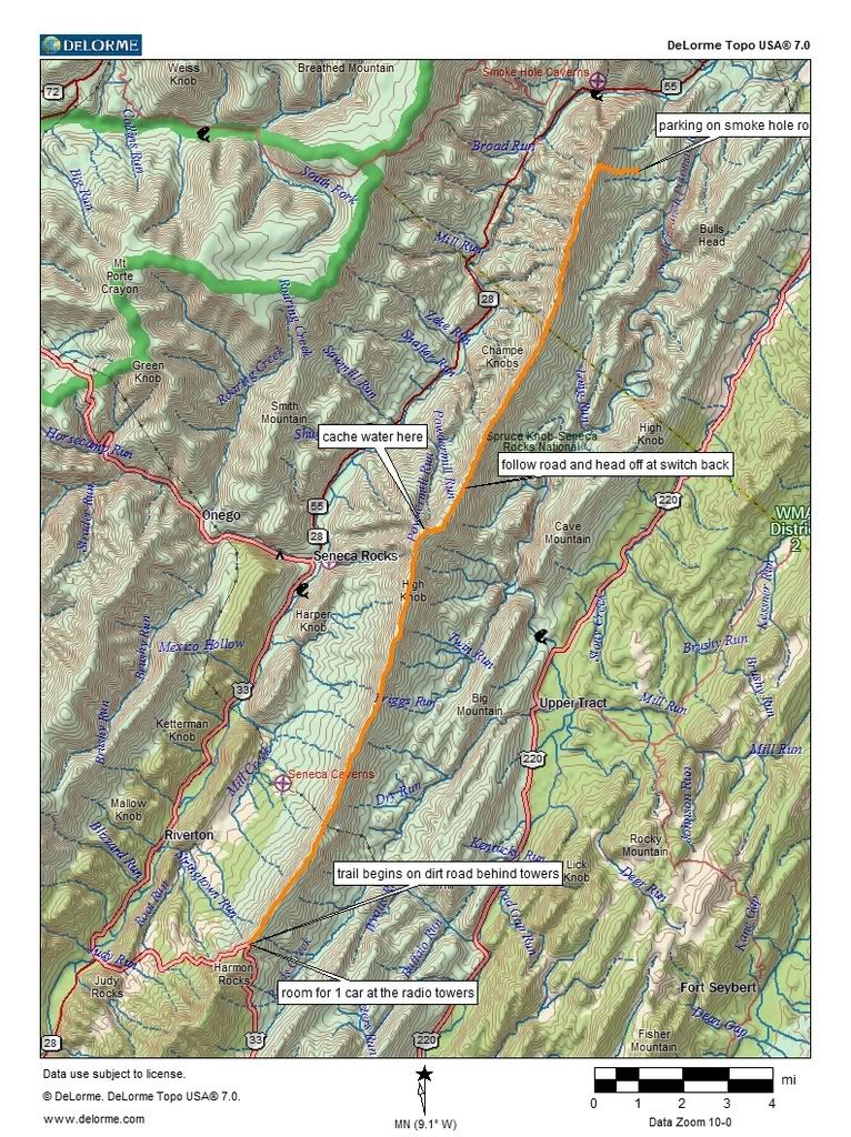
 I made a vow on July 4th, 2005 that I would spend Independence Day weekend in 2006 thru-hiking the short 23.8 mile North Fork Mountain trail in West Virginia. I started researching the hike in the winter and noted that there are no water sources on this trail, however there was a mountainous fire road that led to a place I could use for a water drop at the 10-mile mark.
I knew that I would be biting off more than I could chew if I went alone because a vehicle drop would be required so I put notice of my intentions on the Outdoors Club board and hoped for the best. 2 other backpackers, both of which I knew, decided to take their chances with me as group leader and make the trek.
On Saturday, we left Keith’s car at the endpoint and proceeded on the fire road (FR79) for the water drop with the minivan. My poor car made it to the peak on low gear and I smoked my brakes on the way down. A rock in the road put a huge scrape in my oil pan too. But we managed to leave several gallons of water at the radio towers. The trailhead at the south end is off of Route 33 near Judy Gap, one needs to go to the electrical substation at the top of the ridge and the trail begins at the private entrance behind it.
The views on both sides, east and west,

of the trail are breathtaking. You get a great view of Dolly Sods, Seneca Rocks and even Spruce Knob if it is clear,

just a great feel for the entire Monongahela Mountain Range to the west. However, since you are on a ridgeline, expect there to be wind. Since it was warm the wind cooled us down,
 but at night the noise from the gusts were a bit irritating. If you attempt this trail in winter I would suspect you would need really warm clothing.
We camped near a great view of Seneca Rock the first night, and then a wonderful view of

Yellow Rocks the next. Howard had been purchasing new gear for weeks before this hike, and I was glad to see that he had amassed the necessary gear, and a few extra pieces to make the hike a success. We passed some sort of multi-state science youth group along the way, kids had came from every corner of the country including Mississippi (who thought the area was very mountainous) and Alaska (who thought the area was a little flat). They seemed better behaved than I would have been at that age.
We were glad to see our water stash at the radio tower, filled our bottles and bladder,
 then we washed up as best we could with the remaining water. It got hot and buggy the second day. We managed to walk 11 miles on Sunday but Howard finally staged a mutiny and refused to go any further so we set camp. When we woke up Monday morning we used up the rest of our water for breakfast, then it began to rain. The rain cooled us down, and gave us an opportunity to rehydrate by licking the rainwater off the leaves. Keith speculated whether we were going to get sick from doing so. So far we all seem okay and none the less worse for wear.
We walked the last 5 miles after it cleared up and without incident,

Keith took a nap at the overlook. We actually met someone from West Virginia hiking along the way which was the first time ever I had met a West Virginian on a hiking trail, maybe this state is ready to get healthy after all.
We had a pretty good time.

3 comments:
I'm a native West Virginian, and I hike all of the time. I agree that there are alot of grossly out of shape, over-weight people here (especially the really big ones who ride around on moterized carts while shopping at Wally-Mart), but from what I have observed, it is not only limited to West Virginia. This is a national health crisis. I like your web site, and enjoy your sense of humor.
WVwanderer
http://wvwilderness.blogspot.com/
Nice way to spend the 4th. Great breath taking views. Purple Mountains Majesty! Well almost purple.
Looked like fun. Sorry I missed it.
Post a Comment