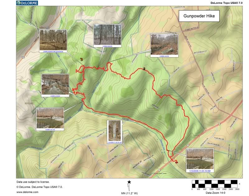
Really people, I need to seriously get a life. I used Earthmate Image Tagger which is some free software from DeLorme to coordinate my DeLorme Earthmate GPS PN-20 GPS Data with pictures taken with my
Olympus SP-550 UZ camera. The result is thumbnails placed at the exact location of my hike using DeLorme TOPO 7.0 mapping software.
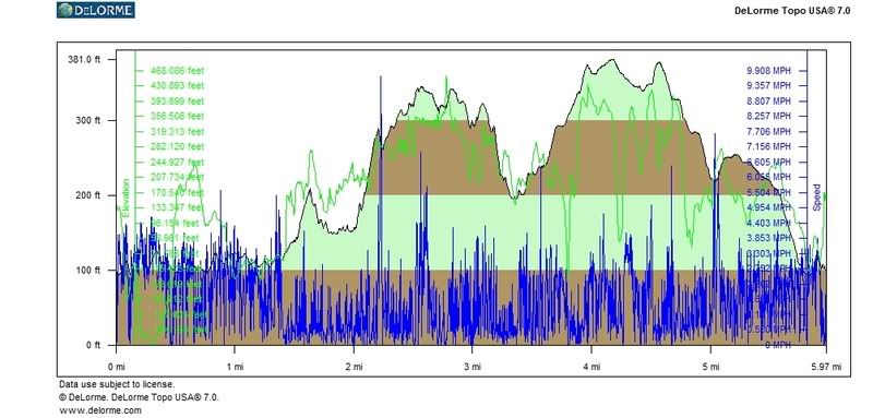
I have attached the profile generated from the tracks off the GPS. Perhaps this is all TMI.
There is a way to coordinate a HRM, but there has to be a point where all this insanity must stop. Enough already.


4 comments:
Cham,
At last, I now know someone who has a PN-20. I've been thinking about getting one for months. Did you buy it in a store locally where you could look at it first? Where? Can you post a review?
How's the battery life?
How's the display?
How easy would it be to read mounted to my handlebars?
Drew:
First of all, I have linked this to the DeLorme forum, so I am not going to say how I got my greasy hands on my precious PN20 but it is a great story and I will tell it to you on email.
The PN20 is the mothership for outdoor enthusiasts. With the unit these days comes precut maps, which means you don't have to buy additional software/maps and you don't have to waste your valuable time playing cut-paste-export with your device and your computer every time you wish to step out the door. This comes in handy when you own the states of Maryland and Virginia but then suddenly decide you need to take an impromptu trip to Idaho.
I am hesitant to post a review of the device because I am not fully maximizing this little machine's capabilities and, perhaps, I never will. As a backpacker I am sometimes out in the woodsy woods for days so I have to economize on battery life or take a boatload of batteries which I won't. So, most times I am merely using the machine in a "how lost have I got myself this time?" function rather than keeping it on for the entire duration of my route. As a bike rider, your experience with the machine will be vastly different.
One of the first things that happened after I received my PN20 was that a bear ate my manual, I am not kidding. I have never bothered to print an additional one from the DeLorme site but I haven't really needed it. I can't say that this is the most intuitive device on the market but if you are already familiar with GPS units it is pretty easy to pick up the basics.
I don't own a ruler but the screen is maybe 1.4"x1.8", no not a 42" plasma but you don't really need it. The best thing about the screen in the back-lighting, you can actually see what is going on in full sun. It take 2 AA batteries and they are probably good for about 6-8 hours, but not much more than that, so you would have to carry around an extra set for your rides.
If the precut maps don't work for you, you can download USGS quads and aerial software via Netlink. DeLorme, like a good drug pusher, gives you a $100 coupon to start your addiction to this process. I've been avoiding this because I hear the detox can be hell.
Here is a link to a discussion about ram mounts. Yes, you can get them for the PN-20. You should be able to read the device while on your bike without a problem. The device is waterproof, as I have already dropped mine in a stream on Christmas.
But that isn't the best part of the whole thing. The very bestest thing about DeLorme is that they have an office filled with human beings that answer the phone(in real American English!). Any question can be answered, DeLorme also has an army of beta people that will bend over backwards on the forum to get your straight as soon as possible. DeLorme is very nice even to crazy ladies that show up on their doorstep screaming bloody murder about TOPO software that doesn't work.
Take that National Geographic!
If I might suggest a walk, here it is:
Start the park and walk at rt 1.
Head down river on the right hand side (not much of a trail on the opposite bank)
Not sure how far it is but you will come to a spot that was maybe still is known as Pot Rocks. The pot part will be obvious if you get there. Nice summertime swimming hole.
Continuing downstream next notable feature is a small cliff.
Another bit of walk and you come to a spot called the "long calm" here you will find at its end the remnants of a log dam that diverted the river into a mill race, used for the Gunpowder Forge a bit downstream. When you get to the end of the "Olde Forge Road" you will be at the works. Just before is the remains of a bridge. Brown's swimming hole to the old locals. At this point you will be in sight of the JFK. Hurricane Agnes left debris on top of the bridge pylon supports. Lots of iron slag and coke residue can be found along the river below the JFK. Short walk to rt 7 and the Big Falls Inn (biker bar on weekends). They ( not the bikers) tore down an old furnace to put in whatever that is. The road you will walk on leads to an old whiskey distillery, there is a concrete dam just before the river becomes tidal. The buildings are gone, debris remains as well as the "turtle tank" up in the woods.
Interesting part here is how fast the river drops from rt 7 to the point it becomes tidal just above the B&O trestle. Great run in a tube, in high water after a thunderstorm. It rocks. I was told something like a 27 ft drop from rt 7 to tidal.
Lots of history along the Gun Powder, tragic that the native flowers are being over run by day lilies an invasive species.
A late spring time walk might happen you upon ram's head orchid, and yellow lady slippers in the vicinity of the long calm although not on the right hand bank.
I grew up and played in and on the Gun Powder and learned how " to walk."
Feeling a need to take a walk with an old friend.
correction to earlier post should have been Showy Orchis not ram's head.
http://www.delawarewildflowers.org/0878.html
that's the one. Sorry about confusion over common names.
Post a Comment